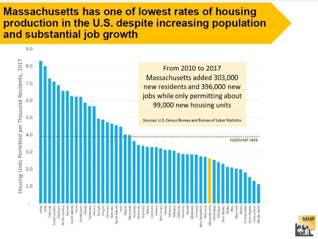
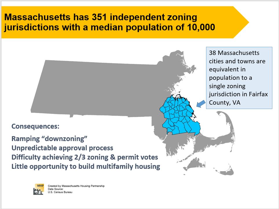
Data in a Mass Housing Partnership report shows how far behind the Boston metropolitan area has fallen in meeting the housing needs of its citizens. There are four primary categories for measuring the inadequacies: 1. Availability, 2. Affordability, 3. L0cation and Mobility and 4. Equitability. See the full report for more data and examples. Two slides are shown below.
Related articles
Last Spring, as Town Meeting considered zoning options for increasing the amount of housing, including affordable housing in Arlington, some citizens rallied against this effort. The reason: Housing is built by developers. Developers are greedy and can not be trusted. Ergo the community must prohibit developers. But much of the Arlington now cherished was planned and built by developers.
This article from the New York Times helps shed a perspective on the role of developers and suggests ways they are critically important to improving and revitalizing communities over time. Yes some developers’ interests may diverge from the community’s interests. Clear land use planning and regulations make it a better opportunity for both sides. Good developers bring skills in planning, finance, architecture and community engagement. They work with the risk that if they do the job well, they make some money. They could lose money. They don’t get paid by the hour. Both sides, community and developer, take risks. But there are rewards for each side too when the sides work together.
This is the second in a series of “Arlington 2020” articles. The first article looked at the number of one-, two-, and three-family homes and condominiums in Arlington, and how that housing stock has changed over time. This article will examine changes in the value of those properties. We’re going to look at “value” through the lens of property assessments, so we should start with an explanation of what property assessments are and how they’re used.
A property assessment is simply the Town Assessor’s best estimate of what a property is worth, based on market values. The assessor’s office inspects properties every ten years; during intervening years, assessments are adjusted based on sale prices of similar homes in a given tax neighborhood. For all practical purposes, assessed values tend to trail market values by two years. In my neighborhood, property assessments are spot on — my house was assessed at $501,000 in 2020; during 2018, sales of similar homes in the neighborhood ranged from $495,000 to $520,000.
Condominiums have a single assessed value, which includes land and buildings. Otherwise, assessed values are broken down into land value, building value, and yard items (e.g., a garage or a shed).
Assessed values are used to determine the tax rate. The assessors page on the town website has calculations in worksheet form, but for all practical purposes, it’s just a division problem. One takes the total tax levy and divides by the sum of all property assessments (in thousands of dollars), and that’s the tax rate. An individual’s taxes are the assessed value of their property (in thousands of dollars) multiplied by the tax rate. If an individual owns (say) 1% of the assessed value in town, that individual will pay 1% of the property tax levy.
The main point is that assessed values are based on market values, but with a two-year lag. Consequently, we can use them as a way to see how home prices have changed over time.
With that background information out of the way, we can look at some numbers. Here’s a graph of the median assessed values for condominiums, one-family, two-family, and three-family homes from 2013 through 2020. (the “median” is a value such that half of the assessments are above, and half are below).
year | Condominium | Single Family | Two-family | Three-family |
2013 | $297,800 | $472,850 | $532,650 | $581,600 |
2014 | $300,150 | $484,400 | $530,000 | $574,800 |
2015 | $318,200 | $507,900 | $572,000 | $616,300 |
2016 | $351,050 | $546,300 | $623,150 | $673,550 |
2017 | $357,750 | $581,200 | $663,900 | $714,800 |
2018 | $395,400 | $618,800 | $732,100 | $787,600 |
2019 | $463,250 | $701,550 | $851,200 | $897,500 |
2020 | $473,100 | $771,900 | $944,000 | $1,010,850 |
%change | 58.87% | 63.24% | 77.23% | 73.81% |
As one would expect, two-family homes are worth more than single-family, and three-family are worth more than two. Condominiums have a lot of variety; they could be half of a duplex, or a single unit in an apartment building. But a general upward trend is clearly evident.
These values are straight out of the assessor’s database, and not adjusted for inflation. The Bureau of Labor Statistic’s inflation calculator shows 12% inflation between 2013 and 2020; the %change is pretty considerable, even if one deducts 12% for inflation.
Next, I’d like to dig further into the 1–3 family assessments, by breaking them down into the value of land vs the value of buildings, and showing how that’s changed over time.
Single-family homes:
year | Land value | Building value | Total assessed value |
2013 | $243,700 | $226,300 | $472,850 |
2014 | $253,750 | $227,050 | $484,450 |
2015 | $272,700 | $229,900 | $507,900 |
2016 | $296,400 | $243,950 | $546,400 |
2017 | $326,400 | $246,400 | $581,250 |
2018 | $360,900 | $248,100 | $618,800 |
2019 | $440,400 | $250,400 | $701,600 |
2020 | $448,600 | $316,300 | $771,900 |
%change | 84.08% | 39.77% | 63.24% |
Two-family homes:
year | Land value | Building value | Total assessed value |
2013 | $202,500 | $320,550 | $532,650 |
2014 | $212,250 | $307,800 | $530,000 |
2015 | $256,400 | $309,800 | $572,000 |
2016 | $262,500 | $349,400 | $623,150 |
2017 | $307,000 | $350,700 | $663,900 |
2018 | $352,500 | $373,900 | $732,100 |
2019 | $478,300 | $374,850 | $851,700 |
2020 | $454,500 | $486,100 | $944,000 |
%change | 124.44% | 51.65% | 77.23% |
Three-family homes:
year | Land value | Building value | Total assessed value |
2013 | $200,100 | $377,900 | $581,600 |
2014 | $209,100 | $364,100 | $574,800 |
2015 | $249,800 | $366,550 | $616,300 |
2016 | $259,950 | $412,350 | $673,550 |
2017 | $298,100 | $412,500 | $714,800 |
2018 | $343,050 | $438,800 | $787,600 |
2019 | $459,000 | $440,100 | $897,500 |
2020 | $440,100 | $578,450 | $1,010,850 |
%change | 119.94% | 53.07% | 73.81% |
There are several things worth pointing out in these breakdowns.
First, note that the land and building values “jump” a bit between 2019–2020. 2020 was one of our full reassessment years, so I’m willing to attribute this to a periodic course correction. The total increase is generally linear, but the land/building composition has changed.
Second, the median land value for single-family homes is higher than the median building value, for all years between 2013–2020.
Third, most of the increases come from changes in land value. I believe this comes down to location, location, and location. Arlington has a well-respected public school system, and it’s close to universities and tech centers is Cambridge and Boston, and office parks in Lexington, Waltham, and Burlington. City amenities are close at hand.
So what does one do about our rising home prices, and in particular, the rising value of land? The first (and perhaps default) answer is to do nothing. Rising property values are a boon to homeowners who purchased a capital asset (i.e., a house) in the past, and have seen its value appreciate over time. The downside of doing nothing is that each year, increasing housing prices create an ever-increasing income threshold for new residents.
An alternative approach would be to allow more (and smaller) units to be built on each lot. This requires reconstruction or redevelopment, but it allows the cost of land to be amortized among several households. More units/lot means more people and more density, but it reduces the income threshold for buying in to Arlington. (Note that the per-unit cost for three-family homes is lower than the per-unit cost for two-family homes. Similarly, the per-unit cost for two-family homes is lower than the cost of a single-family home).
A third article will look at the distribution of housing prices in Arlington, and how the distribution varies by housing type.
Here is a spreadsheet of data shown in this post.
A report by Mass Housing Partnership’s Shelly Goehring looks at Arlington’s housing development history and policies to understand how municipal action and inaction can contribute to housing inaffordability and can limit the population diversity within a community. The report implies that it has been difficult historically for reputable housing developers to work with the regulatory structure within Arlington to get housing built.
Massachusetts has the nation’s 2nd largest gap in homeownership between households of color (31% own homes) and white households (69% own homes).
See the complete report for more information.
Does Arlington need more housing? If yes, will more housing result in higher school costs? There is a perception that more housing means more school age children and more school age children will strain the capacity and expand the budget of the Arlington Public Schools.
Prelimary reviews suggest that more housing would not strain the APS capacity for a variety of complex reasons. These reasons include: school age children do not always go to APS; by the time new housing came on line, the school enrollment, now growing, will have begun to decline; Arlington needs more diverse kinds of housing, not just family housing; the 283 units of housing that came on line through Brigham Square and 360 contributed more in property tax revenue than they cost in school enrollment costs…. by over $980K in 2019. Read this for more information.
More analysis is needed. More discussion is needed. These are complicated and nuanced issues. Readers with additional comments should send them to info@equitable-arlington.org.
The material in this post came from my efforts to learn about when Arlington’s housing was built. The data comes from the town’s 2019 property tax assessments, where I took our nineteen-thousand-and-some-odd homes and apartments and broke them down by housing type and decade built. It’s not exactly a history housing of production, though it is a close approximation. In this analysis, a single-family home built in the 1912 and rebuilt as a two-family in 1976 would show up as two units built in the 1970s. Similarly, a three-family home that was built in the 1924 and later converted to condominiums would show up as three condominiums built in the 1920s.
Here’s the visual summary:
And here’s a small spreadsheet with the underlying numbers.
My first surprise was at how much we built in the 1920s: just under five thousand units. This was our biggest decade for housing production, and nearly double our second biggest (the 1950s). Another surprise was the 1990s; 132 of our homes were constructed during that decade, which is the smallest number since the 1870s.
What about homes constructed before 1850? There are only 117 of them, and they’re omitted from the data set. I’ve also omitted residential units in mixed-use buildings, since my copy of the assessors data doesn’t break mixed-use buildings into residential and non-residential units.
As the public hearings on the zoning articles proceeded in late winter and early spring, 2019, it became clear that there was a very strong sentiment that the proposed increase in density in these designated zoning districts should result in an increase in affordable housing in Arlington. This coincided with the approved 2015 Master Plan’s stated goals:
- Encourage mixed-use development that includes affordable housing, primarily in well-established commercial areas.
- Provide a variety of housing options for a range of incomes, ages, family sizes, and needs.
- Preserve the “streetcar suburb” character of Arlington’s residential neighborhoods.
- Encourage sustainable construction and renovation of new and existing structures (see ch. 5, pg 77++ for housing section)
- The Yes on 16 report supports the citizen initiated petition resulting in Article 16 and demonstrates the tremendous impact of rapidly increasing land values on the overall affordability of property in Arlington. Building a stack of homes on one footprint is far more financially affordable than creating a single home on the same footprint of land.
Seattle finds new tools to preserve neighborhood character in the Pike / Pine Corridor of the city. Arlington has its own neighborhood districts that are now being re-thought with new planning for the neighborhoods’ future. These include the Broadway Corridor, the Mass Ave. Transit Corridor and Arlington Heights.
The tools here include samples for what Arlington might do, “overlay District”, Transfer of Development Potential (TDP). A TDP provides incentives
for property owners to keep existing “character structures” rather than tear them down. A Conservation Core was also established within the district to further ensure that new development is more compatible with the special scale and character of existing development in this area. They also prepared Design Guidelines, Zoning Ordinance, Environmental Review Checklist, Cultural Overlay District, “Center Village” Plan, Inventory of Historic Resources, etc.
(published June, 2019)
Overview
To solve the extraordinarily large deficit in housing for the greater Boston region, over 180,000 units of new housing should come on line in the next few years. This deficit is the result of a rapid expansion in in-migration due to new job creation, with no commensurate increase in housing production for the people taking those new jobs.
The report concludes that zoning is a primary culprit in restricting the development of an adequate housing supply, creating a “PAPER WALL” keeping out newcomers. The cost of this inadequate supply is a huge demand for housing which, in turn, bids up the price for available housing. The following “culprits” are considered: inadequate land area zoned for multi-family housing; low density zoning; age restrictions and bedroom restrictions; excessive parking requirements; mixed use requirements and approval processes. Alternative zoning models are suggested.
Elements such as “Approval Process”, “Mixed Use”, “Village Centers vs Isolated Parcels” and “Building Up or Building Out” are considered.
Researcher Amy Dain reports on two years of research into the regulations, plans and permits in the 100 cities and towns surrounding Boston. The research was commissioned by the Massachusetts Smart Growth Alliance and funded collaboratively with: Citizens’ Housing and Planning Association, Home Builders & Remodelers Association of Massachusetts, Massachusetts Association of Realtors, Massachusetts Housing Partnership, MassHousing, and Metropolitan Area Planning Council.
For the full report see: https://ma-smartgrowth.org/wp-content/uploads/2019/06/03/FINAL_Multi-Family_Housing_Report.pdf
For a power point slide presentation see: https://ma-smartgrowth.org/wp-content/uploads/2019/06/04/DainZoningMFPresentationShare2019.pdf
For the Executive Summary see: https://equitable-arlington.org/wp-content/uploads/2019/07/June-2019-Multi-Family-Housing-Report_Executive-Summary.pdf
No Comments
Leave a comment Cancel