The presentation, dated March 11, 2019, includes slides used to present the information necessary to understand the rationale for zoning changes, the location of the zoning areas under consideration and the charts, tables and maps that help describe the situation. The proposed zoning changes, especially articles 6, 7, 8, 11 and 16, only cover changes affecting about 7% of the Town, those parts of the Town that are currently zoned R4-R7 and the B zoning districts.
Related articles

by Steve Revilak
The term “AMI” or “Area Median Income” comes up in almost any discussion about affordable housing, because it’s used to set rents and the household incomes for people who are eligible to live in affordable dwellings. AMI is a fairly technocratic concept and my goal is to make the concept (and the numbers) easier to understand.
AMIs are set each year by the U.S. Department of Housing and Urban Development; broadly speaking, an AMI is the median income of a region. Arlington is part of the “Boston-Cambridge-Quincy, MA-NH HUD Metro FMR Area” which consists of more than 100 cities and towns in Massachusetts and New Hampshire. Median incomes represent the “middle” family income of an area—half of households make more, and half make less.
In the process of turning median incomes into income limits, HUD also considers household size: larger households are assigned larger AMI limits than smaller ones, in order to reflect the higher cost of living for more family members.
How do these limits translate into affordable housing regulations? Arlington’s affordable housing requirements (aka “inclusionary zoning”) require that rents for affordable units be priced for the 60% area median income, but the dwellings are available to households making up to 70%. Let’s show an example with some numbers.
| Household size | 60% Income Limit | 70% Income Limit | 60% Rent |
|---|---|---|---|
| 1 | $68,520 | $79,940 | $1,717/month |
| 2 | $78,360 | $91,420 | $1,959/month |
| 3 | $88,140 | $102,830 | $2,203/month |
HUD considers an apartment suitable for a household if it has one bedroom less than the number of household members, so a two-bedroom apartment would be suitable for a household of three, a one-bedroom would be suitable for a household of two, and a studio would be suitable for a household of one. The monthly rent for a two-bedroom apartment would be calculated as follows: $88,140 ÷ 12 × 30% = $2,203. The 30% comes from HUD’s rule that affordable housing tenants should not be cost-burdened, meaning that they pay no more than 30% of their income in rent.$88k or $102k/year can seem like a lot of money (and once upon a time it was). To get a better sense of what these income levels mean, I looked into what kinds of jobs pay these wages. To that end, I found wage information from the Arlington Public Schools report to Town Meeting, the Arlington town budget, and wage data from the Bureau of Labor Statistics. Here are a few scenarios:
Scenario 1: single adult
Scenario 1 represents a single adult living alone, and earning between $68,520 and $79,940. Jobs in this pay range include:
- Elementary classroom teacher ($62,000 – $75,000)
- Town planner ($75,000 – 79,000)
- Animal Control Officer ($72,000)
- Firefighter ($73,640)
- Librarian ($70,395)
- Lab Technician ($70,710)
- Social Worker ($71,470)
- Subway operator ($72,270)
- Licensed Practical Nurse ($75,690)
- Paralegal ($77,500)
- Chef ($78,040)
- Carpenter ($78,000)
Scenario 2: single parent with household of two
Scenario 2 represents a single parent earning between $78,360 and $91,420/year. Jobs in this pay range include:
- Office Manager – Assessor’s office ($80,399)
- Assistant Town Clerk ($77,375)
- Town Engineer ($74,000 – $80,000)
- Police Department Patrol Officer ($87,000)
- Town Budget Director ($88,488)
- Telecommunications equipment installer ($80,350)
- Plasterer and Stucco Mason ($82,250)
- Electrician ($82,380)
- Cement Mason ($86,250)
- Plumber and pipe fitter ($90,580)
Scenario 3: household of two, both adults
Scenario 3 has two adults, each earning $39,180 – $45,710 per year. Jobs in this salary range include several that we’ve come to know as “essential workers” during the pandemic.
- Special education teaching assistant ($34,290)
- Arlington Public Schools Paraprofessional ($36,290 – 42,440)
- Substitute Teacher ($34,921)
- Inspectional Services Record Keeper ($44,481)
- Food preparation worker ($39,590)
- Bartender ($39,730)
- Childcare worker ($40,470)
- Ambulance Driver ($40,890)
- Waiter ($41,440)
- Pharmacy aide ($41,460)
- Bank teller ($42,270)
- Tailor and dressmaker ($43,790)
- Restaurant cook ($44,140)
You may have noticed gaps in these lists — for example, there are no jobs listed in the $50,000 – $60,000 range because it’s in between the income limits for one- and two-income households. It’s also worth noting that a fair number of town employees’ salaries would qualify them for affordable housing (the town is Arlington’s largest employer).
So who qualifies to live in affordable housing? People with a lot of ordinary, working-class jobs, including many town employees.
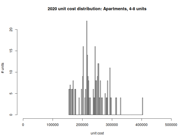
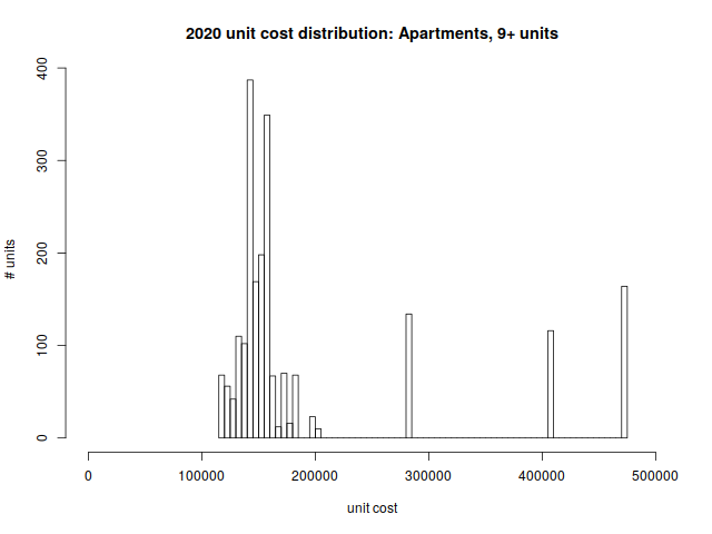
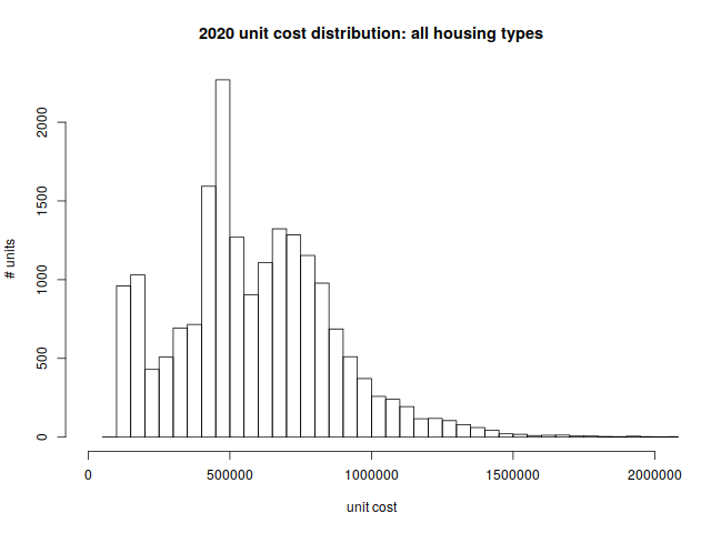
The cost of building a residential unit, single or multi-family, correlates directly, if not precisely, with its cost to resident tenants or owners. The following study and data (using Assessor’s data) demonstrates that higher density housing is more affordable than single-family housing. Whether you look at the median cost of all housing across the Town or the unit costs of the newer, more expensive, apartments built in the last decade, density yields lower prices. The town wide median is $438,900 per unit.
The newest projects (420-440 Mass Ave., Brigham Square and Arlington 360) range from $249k per unit to $412K per unit. These three developments alone contributed 414 new units of housing to the Town.
Discussions of “affordability” represents a spectrum of terms. Units can be affordable because zoning and market conditions allow the units to be built for less money than a single family home. Or they can be affordable because the builder has received subsidies that reduce the cost. Or they can be affordable, as in the case of inclusionary zoning, because the permission to build is contingent on at least some of the units being “permanently” (99 years) available to qualified tenants or buyers based on legal restrictions.
The new proposal is just the most recent step in a process that reaches back almost a decade, culminating in the Master Plan (2015), the Housing Production Plan (2016) and the mixed-using zoning amendments of 2016. The Town has consistently proposed smart growth: more development along Arlington’s transit corridors to increase the tax base, stimulate local commerce, and provide more varied housing opportunities for everyone, including low and moderate income Arlingtonians. This year’s proposals are no head-long rush into change. Today’s debate is similar to the debate before Town Meeting three years ago. If anything, progress has been frustratingly slow. To realize the Master Plan’s vision of a vibrant Arlington with diverse housing types for a diverse population, we must stay the course on which we have been embarked for so long.
As the public hearings on the zoning articles proceeded in late winter and early spring, 2019, it became clear that there was a very strong sentiment that the proposed increase in density in these designated zoning districts should result in an increase in affordable housing in Arlington. This coincided with the approved 2015 Master Plan’s stated goals:
- Encourage mixed-use development that includes affordable housing, primarily in well-established commercial areas.
- Provide a variety of housing options for a range of incomes, ages, family sizes, and needs.
- Preserve the “streetcar suburb” character of Arlington’s residential neighborhoods.
- Encourage sustainable construction and renovation of new and existing structures (see ch. 5, pg 77++ for housing section)
- The Yes on 16 report supports the citizen initiated petition resulting in Article 16 and demonstrates the tremendous impact of rapidly increasing land values on the overall affordability of property in Arlington. Building a stack of homes on one footprint is far more financially affordable than creating a single home on the same footprint of land.

The kick-off event for updating Arlington’s Comprehensive Plan (formerly called the Master Plan) is just around the corner on April 3rd from 7-8:30 PM in the Arlington High School Cafeteria!
A Comprehensive Plan is a long-range plan for the Town, and an opportunity for the community to come together and imagine what Arlington could look like in ten or fifteen years. It covers things like housing, business development, parks and open spaces, town services and facilities, and transportation. The kickoff meeting is the first step in building that vision.
Arlington residents of all ages are invited to attend this event, where you can expect a presentation followed by small group discussions. The effort will continue throughout the year, and it’s important to hear from as many residents as possible. Please join if you can!
For more information and to add the meeting to your calendar, see ArlingtonMA.gov/CompPlan.
This is the second in a series of “Arlington 2020” articles. The first article looked at the number of one-, two-, and three-family homes and condominiums in Arlington, and how that housing stock has changed over time. This article will examine changes in the value of those properties. We’re going to look at “value” through the lens of property assessments, so we should start with an explanation of what property assessments are and how they’re used.
A property assessment is simply the Town Assessor’s best estimate of what a property is worth, based on market values. The assessor’s office inspects properties every ten years; during intervening years, assessments are adjusted based on sale prices of similar homes in a given tax neighborhood. For all practical purposes, assessed values tend to trail market values by two years. In my neighborhood, property assessments are spot on — my house was assessed at $501,000 in 2020; during 2018, sales of similar homes in the neighborhood ranged from $495,000 to $520,000.
Condominiums have a single assessed value, which includes land and buildings. Otherwise, assessed values are broken down into land value, building value, and yard items (e.g., a garage or a shed).
Assessed values are used to determine the tax rate. The assessors page on the town website has calculations in worksheet form, but for all practical purposes, it’s just a division problem. One takes the total tax levy and divides by the sum of all property assessments (in thousands of dollars), and that’s the tax rate. An individual’s taxes are the assessed value of their property (in thousands of dollars) multiplied by the tax rate. If an individual owns (say) 1% of the assessed value in town, that individual will pay 1% of the property tax levy.
The main point is that assessed values are based on market values, but with a two-year lag. Consequently, we can use them as a way to see how home prices have changed over time.
With that background information out of the way, we can look at some numbers. Here’s a graph of the median assessed values for condominiums, one-family, two-family, and three-family homes from 2013 through 2020. (the “median” is a value such that half of the assessments are above, and half are below).

| year | Condominium | Single Family | Two-family | Three-family |
| 2013 | $297,800 | $472,850 | $532,650 | $581,600 |
| 2014 | $300,150 | $484,400 | $530,000 | $574,800 |
| 2015 | $318,200 | $507,900 | $572,000 | $616,300 |
| 2016 | $351,050 | $546,300 | $623,150 | $673,550 |
| 2017 | $357,750 | $581,200 | $663,900 | $714,800 |
| 2018 | $395,400 | $618,800 | $732,100 | $787,600 |
| 2019 | $463,250 | $701,550 | $851,200 | $897,500 |
| 2020 | $473,100 | $771,900 | $944,000 | $1,010,850 |
| %change | 58.87% | 63.24% | 77.23% | 73.81% |
As one would expect, two-family homes are worth more than single-family, and three-family are worth more than two. Condominiums have a lot of variety; they could be half of a duplex, or a single unit in an apartment building. But a general upward trend is clearly evident.
These values are straight out of the assessor’s database, and not adjusted for inflation. The Bureau of Labor Statistic’s inflation calculator shows 12% inflation between 2013 and 2020; the %change is pretty considerable, even if one deducts 12% for inflation.
Next, I’d like to dig further into the 1–3 family assessments, by breaking them down into the value of land vs the value of buildings, and showing how that’s changed over time.
Single-family homes:

| year | Land value | Building value | Total assessed value |
| 2013 | $243,700 | $226,300 | $472,850 |
| 2014 | $253,750 | $227,050 | $484,450 |
| 2015 | $272,700 | $229,900 | $507,900 |
| 2016 | $296,400 | $243,950 | $546,400 |
| 2017 | $326,400 | $246,400 | $581,250 |
| 2018 | $360,900 | $248,100 | $618,800 |
| 2019 | $440,400 | $250,400 | $701,600 |
| 2020 | $448,600 | $316,300 | $771,900 |
| %change | 84.08% | 39.77% | 63.24% |
Two-family homes:

| year | Land value | Building value | Total assessed value |
| 2013 | $202,500 | $320,550 | $532,650 |
| 2014 | $212,250 | $307,800 | $530,000 |
| 2015 | $256,400 | $309,800 | $572,000 |
| 2016 | $262,500 | $349,400 | $623,150 |
| 2017 | $307,000 | $350,700 | $663,900 |
| 2018 | $352,500 | $373,900 | $732,100 |
| 2019 | $478,300 | $374,850 | $851,700 |
| 2020 | $454,500 | $486,100 | $944,000 |
| %change | 124.44% | 51.65% | 77.23% |
Three-family homes:

| year | Land value | Building value | Total assessed value |
| 2013 | $200,100 | $377,900 | $581,600 |
| 2014 | $209,100 | $364,100 | $574,800 |
| 2015 | $249,800 | $366,550 | $616,300 |
| 2016 | $259,950 | $412,350 | $673,550 |
| 2017 | $298,100 | $412,500 | $714,800 |
| 2018 | $343,050 | $438,800 | $787,600 |
| 2019 | $459,000 | $440,100 | $897,500 |
| 2020 | $440,100 | $578,450 | $1,010,850 |
| %change | 119.94% | 53.07% | 73.81% |
There are several things worth pointing out in these breakdowns.
First, note that the land and building values “jump” a bit between 2019–2020. 2020 was one of our full reassessment years, so I’m willing to attribute this to a periodic course correction. The total increase is generally linear, but the land/building composition has changed.
Second, the median land value for single-family homes is higher than the median building value, for all years between 2013–2020.
Third, most of the increases come from changes in land value. I believe this comes down to location, location, and location. Arlington has a well-respected public school system, and it’s close to universities and tech centers is Cambridge and Boston, and office parks in Lexington, Waltham, and Burlington. City amenities are close at hand.
So what does one do about our rising home prices, and in particular, the rising value of land? The first (and perhaps default) answer is to do nothing. Rising property values are a boon to homeowners who purchased a capital asset (i.e., a house) in the past, and have seen its value appreciate over time. The downside of doing nothing is that each year, increasing housing prices create an ever-increasing income threshold for new residents.
An alternative approach would be to allow more (and smaller) units to be built on each lot. This requires reconstruction or redevelopment, but it allows the cost of land to be amortized among several households. More units/lot means more people and more density, but it reduces the income threshold for buying in to Arlington. (Note that the per-unit cost for three-family homes is lower than the per-unit cost for two-family homes. Similarly, the per-unit cost for two-family homes is lower than the cost of a single-family home).
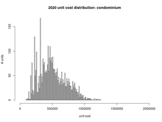
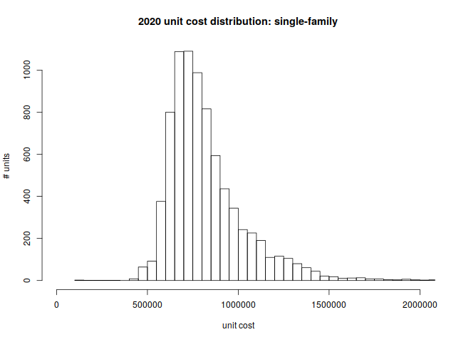
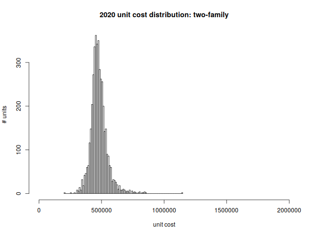
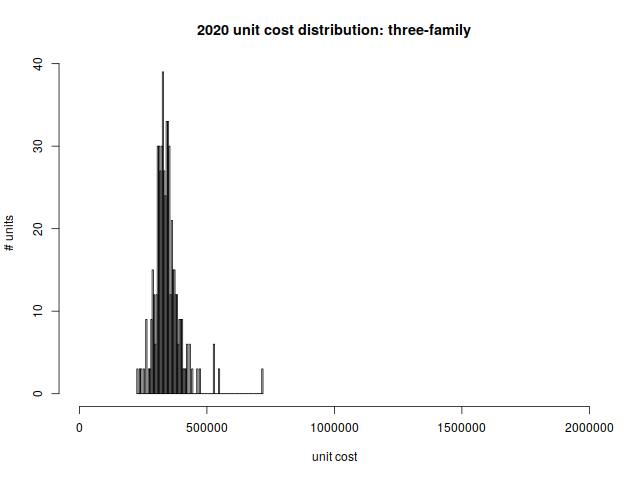
A third article will look at the distribution of housing prices in Arlington, and how the distribution varies by housing type.
Here is a spreadsheet of data shown in this post.
(DRAFT – 7/11/2019)
Overview

Arlington Planning Department officials report on options for the Town to mitigate the effects of housing demolitions and housing replacements in neighborhoods.
Evidence suggests that lack of appropriate regulatory policies have led to incidences of “mcmansions” and other issues that concern neighborhood residents. This study looks at the data, the policy and regulatory options for Arlington. It also looks at how comparable nearby communities have managed similar circumstances.
This 42 page report covers a great deal of data and analysis of homes by zoning district, gaps in the effectiveness of the current regulatory structure, affects on affordability in Arlington by zoning district, information on housing prices and sales, etc.
“Best practices” include descriptions of demolition delay, expansion of local historic districts, neighborhood conservation districts, design review standards and guidelines and possible revisions to the regulatory framework in Arlington. The report also includes interesting case examples of how comparable communities near Arlington handle these issues.
This report was presented to the Arlington Select Board on July 22.
Read the complete report and see the available data and tables.
by Alexander vonHoffman, Joint Center for Housing Studies, Harvard University, February 2006
The case study shows that in the 1970s the Town of Arlington completely abandoned its policy of encouraging development of apartment buildings—and high-rise buildings at that—and adopted requirements that severely constricted the possibilities for developing multifamily dwellings. Although members of the elite introduced the new approach, they were backed by rank-and-file citizens, who took up the cause to protect their neighborhoods from perceived threats.
The report outlines an intentional effort using land use and planning tools like zoning and building approvals, to exclude those with less desirable income or racial characteristics from residing in Arlington. Additional perspectives on Arlington’s exclusionary zoning efforts during this period are reported here.